GÜNDOĞMUŞ
Gündoğmuş district is 153 km from Antalya. east of the Akseki-Konya road 32 km. is located in the south. The distance to Alanya is 70 km and the distance to Manavgat is 70 km. The present Gündoğmuş region was divided into Senir and Çündüre regions before the establishment of the Republic. In the Middle Ages, political relations were mostly with Alaiye accident or Sanjak. After Alaiye was reduced to an accident status at the end of the 19th century, we see that she continued her political life partly due to Akseki. They had administrative loyalties under the name of Karaman Province, Konya Sanjak or Teke Sanjak. In some records Konya Province, Teke (Antalya) Sanjak, Senir accident is also referred to. It is mentioned in the records of the late 19th century (after 1889) as sub-districts. Senir Düşenbih was sometimes attached to Manavgat sometimes Akseki and sometimes directly to Antalya Teke Principality. Çundur sub-district was mostly associated with Alanya. The name of Gündoğmuş before the district was “Eksere.. While it was a village of Akseki district, it became a district with a law enacted in 1936 and its name was changed to “Gündoğmuş..
Gündoğmuş, whose history dates back to ancient times, was inhabited during the Roman period. Roman ruins within the boundaries of the district, the ruins of Kaseyir in Taşahır Mevkii, the Roman ruins in Kese Mevkii near Senir Village are the oldest ruins. Later, especially after the victory of Manzikert during the Turkification of Anatolia, the city remained under the rule of the Seljuks and II. Bayezid period also joined the territory of the Ottoman Empire.
In this region, the Yoruk gentlemen, who came from the Manavgat gate, which opened to the Turks with the 1071 Malazgirt war from Horasan, settled. These people were called Senir Bey. As this tribe increased in 1820, they descended to the south shore and formed the Manavgat villages today.
Two narrations about the history of Gündoğmuş have been transferred to the provincial annuals.
a- According to the first rumor, Gündoğmuş, who was formerly Eksere, established a family that left the İksile Town of Karaman for various reasons.
b- According to the second rumor, the nomads who lived on the beach in winter would go to the highlands in summer and return again in autumn. Most of this nomadic convoy does not return to the beach. He settles in Gündoğmuş. When asked about the rest of the café on the beach, they say “Most of them stayed.. On this occasion, they call the place where they stayed. Over time, this word begins to be said in the form of Exere.
Another story told is as follows; A group of Muslim Arab soldiers who came to the conquest of Cyprus went to Yeşilköy, a village of Alanya today. From here he proceeds inward to fulfill his duty of notification. In the meantime, they meet the Turks of Khorasan who are completely different from the Greeks in terms of life and character and who seek a beautiful homeland. These are a handful of serdenge, matured by all aspects of nature.
Muslim Arabs do their duty to the Turks. The Turks, who regard Islam as appropriate to their souls in terms of social life, morality and character, accept this sacred religion. “Believers are brothers.” And they exchange girls for girls.
This Islamic community, which was strengthened with the participation of the Turks, marched into the Byzantine homeland of Anatolia. However, Sheikh Mehmet Efendi, who was in the position of religious leaders, stayed here with a group when he fell ill from the vicinity of Saburlar Village.
The first Islamic village in the south, Saburlar Village, which is worthy of glory, was founded by this Sheikh Mehmet Efendi. The weighted portion of the Group proceeds to proceed with the communiqué. The occasional clashes continue until the Ermenek district, which is now connected to Karaman. Here tents are settled in a place suitable for living. In the meantime, a burned dervish goes to a high place and sela and recites azan. Therefore, the name of this place is the FIRST SELA. However, over time, this name is said to be “WITH FIRST” and then as KS İKSILLE..
When the Muslims here multiply over time, Ilksile becomes a big village. They build other villages. One day, a crowded group of Çor-children religious leaders set out to visit Mehmet Efendi and came to the position called by our people (Karain). However, the spring came and melted with snow melting Alara Brook does not give way to these loyal children. They don’t go back to Iksile. Now settled in the ruins of the castle and in the history of Alanya as the name Pambucak. They make a bridge in the following days and facilitate transportation with Saburlar village. But now Pambucak has become a separate village.
When Pambucak is considered dangerous in terms of stockbreeding and enemy raids, a group of Senir and a group of Ortakonuş and a group of people go to the settlements that we call the present village. The relationship between the people of Ortakon and Eksere is still discussed among the elderly.
However, as the inhabitants of Köyiçi get crowded, thirst increases. When the shortage of space starts, they come to Gündoğmuş, which is still a short winter, but a good winter for animal husbandry. As we explained at the beginning of the subject, they first give the name Iksil or Ekseri. In time, it starts to be said as Exere. When the district is named Gundogmus.
Geographical Structure of Gündogmus
It is a district established on the foothills of Geyik Mountain of the Western Taurus Mountains. Its surface area is 1323 km² and its altitude is 900 m. Mountainous areas are covered with forests. Alara Stream divides the district in east-west direction. Although the Mediterranean climate is dominant, it has a slightly more continental climate in winter. Therefore, winter passes a bit harsh. The town of Gündoğmuş, which is 149 km away from Antalya, is connected to the Akseki – Manavgat Highway by a 36 km asphalt road.
Economic Status of Gündoğmuş
The unemployment rate in the district is very high and since the young labor force is directed towards the tourism sector in the coastal districts and towns, the district gives continuous migration. The most important share in the district employment is the Directorate of Forestry, which employs seasonal workers. There is no important industrial establishment in the district. Due to the rugged terrain, the limited agricultural land caused agriculture to be carried out in small terraces. Livestock occupies an important place in villages. Beekeeping occupies an important place in the district economy, including the center. In the villages, vegetables and fruits are grown partially, but only for needs. Seasonal craftsmanship is common and folk go to coastal towns in summer to collect cotton.
Social Status of Gündoğmuş
As archaeological remains; Kaseyir in Taşahır locality, Kese ruins two kilometers east of Senir village, Gedefi ruins in central district, Karadere village, historical ruins in Hisar and Kiliseönü locality, ruins in hills between Penbelik, Çayırözü and Narağacı villages, Karaköy, Bedan and Balur (Akyar / Akyarı) The historical ruins in the village, the yet not excavated in the town of Guzelbag Hagia Sophia. In the district center; Cem Pasha Mosque, which was thought to have been built during the Silifke Governorate, is one of the cultural values of the district. There are many plateaus in the district. Some of them are known by family names such as Aliahmetler, Elibeyler and Kadılar. Another plateau is the plateau. An economic activity in the sense of highland tourism by the discovery of this natural beauty of the district is a subject that has started to develop in recent years. There are also many picnic areas in the district center. This forested area in Pınarbaşı area is under protection and efforts are continuing to make it a national park.
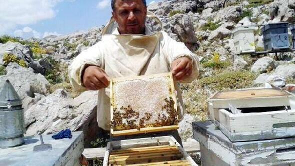
Beekeeping
Beekeeping is common in Gündoğmuş. The unbelievable diversity of plants in the plateaus is one of the reasons why Giigi Honey is preferred. Balancing is a Central Asian profession in Turks. Clean and disease-free air, wetlands and crater lakes, flowers of various colors and vegetation are instrumental in the rapid development of fisheries in Gündoğmuş soil. Supported by the District Directorate of Agriculture and Forestry, the apiculture was diversified with Caucasian bees with high honey yields. Gündoğmuş region, with its historical monuments, plateaus and rivers, crater lakes, unique plant and fruit richness, has witnessed thousands of years of humanity’s adventure as it was seen in many other Anatolian cities, starting with the conquest of Alaiye in 1221.
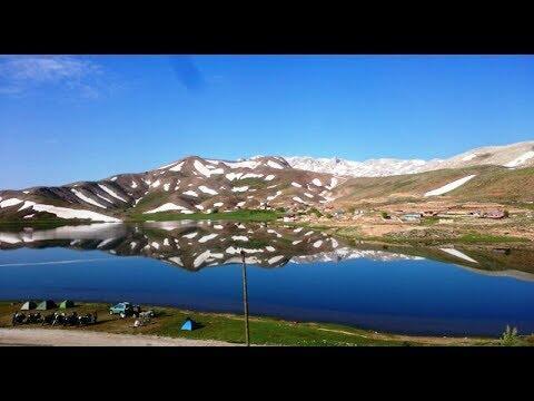
Eğrigöl
Situated on the Taşeli Plateau at the foot of the Geyik Mountains, on the border of Antalya and Konya, Eğrigöl welcomes the people of Yaylacılar, nature and photography lovers and campers with its untouched nature and endemic plants.
Located at the foot of the Geyik Mountains, one of the highest peaks of the Taurus Mountains, Eğrigöl with an altitude of 2,100 meters attracts attention with its plant diversity, crocuses of different colors and endemic plants. The colorful flowers among the meanders formed by the creeks and creeks flowing into the lake create a unique landscape with the snow cover extending through the veins in the mountains. Despite May, the thickness of snow increases to 2-3 meters.